Category: Research
Feedbacks between vegetation and morphology on barrier islands
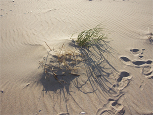
Vegetation is a key contributor to the development of topographic relief on barrier islands, and thus can be influential in determining barrier island susceptibility to overwash. As global temperatures increase, cool-weather grasses that build continuous dunes in the mid-Atlantic coastal zone may be replaced by warm-weather grasses that create hummocky, discontinuous dunes—a change which will likely affect spatial variability in overwash vulnerability. Furthermore, as overwash events become more frequent, dune-building grasses (which increase topographic relief and thrive at high elevations) may be replaced by overwash-adapted maintainer species (which stabilize flat topography and thrive at low elevations), thereby increasing the likelihood of future overwash and reinforcing continued disturbance. We are using both field-based and numerical modeling approaches to investigate the complex, interacting roles of vegetation, sediment, and external physical drivers in barrier island evolution and response to changing climate conditions.
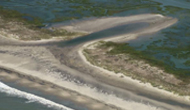
Barrier island evolution under accelerating sea level rise
In order for barrier islands to persist during periods of sea level rise (SLR), they must migrate landward to maintain their elevations relative to sea level. The ability of an individual island to effectively migrate is controlled by complex interactions between many parameters including relative SLR rate, sediment supply rate, underlying stratigraphy, and back-barrier deposition. We are using a morphological behavior model (GEOMBEST) to characterize past evolution and to explore potential future responses of barrier islands in the Virginia Coast Reserve under changing SLR conditions. Specifically, we focus on how variability in back-barrier environment and underlying stratigraphy may influence barrier island behavior.
Barrier island “resilience” to storms
The response of barrier landscapes to storm events can vary substantially at a range of spatial scales, even within an individual barrier island. To characterize alongshore variations in morphological response to and recovery from storm events, we are comparing lidar data collected in the Virginia Coast Reserve both immediately following a severe storm (Hurricane Bonnie, 1998) and during subsequent calm-weather conditions (2005). We define alongshore “resilience,” or relative localized recovery, as the change in the probability of overwash between the post-storm conditions and the more recent calm-weather conditions, and we hypothesize that this resilience is likely related to local morphological characteristics. Using a cutting-edge application of wavelet coherence analysis, we are determining the alongshore positions and spatial scales at which changes in beach morphology covary with resilience, a technique that will ultimately allow us to infer which processes are most important to the post-storm recovery of barrier islands.

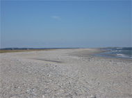
Impacts of changing wave climate on barrier shorelines
Coastal barrier environments are dynamic landscapes that can change dramatically within human timescales. As sea level rises and storminess increases in association with climate change, wave behavior (dominant orientation, power) is also changing, with significant implications for the evolution of coastal landforms. Using a combination of field techniques, remote sensing, and GIS, we are studying the effects of changing wave climate on sediment transport and shoreline shape in the Outer Banks of North Carolina.